View at Parchamo Peak (6250 m) from Trashi Labtse Pass (5700 m).
View at Parchamo Peak (6250 m) from Trashi Labtse Pass (5700 m).
Again I signed up for a trek and climb in Nepal organised by Sponsortrek. This trek will last 23 days and take us across the Trashi Labtse pass of 5700 meters between the Rolwaling valley and Everest Region. We will also try to climb Yalung Ri (5600 m) and Parchamo (6250 m).
The Trashi Labtse pass is about the same altitude as the Elbruz (5600 m) or Kilimanjaro (5800 m) with the difference that we must reach it to cross. The only alternatives are to walk back or be picked up by a helicopter for medical reasons.
Out of the eight group members, five have already been on the Mera Peak trip (6500 m): Jaco, Jeroen, Meinhard, Reinhard and myself. Paul and Jacolien have been on climbing trips in the Alps before and Ron, our marathon runner, finds the Ganesh Himal trip too light. This could be very strong group.
Several factors can influence the trip, e.g. physical shape at high altitude, high altitude sickness, vegetarian food, different food bacteria causing diarrhea, camping on rocky and inclined ground, uncomfortable seats, poor sleep, bright sun, the cold weather high up and Asian colds.
The flight from Amsterdam to Kathmandu takes only 11 hours as since 1998 there is a comfortable flight operated by Transavia, a Dutch Holiday Charter Company. This is very different from the 24 or 30 hours if you go through Qatar, New Delhi or Dhaka
We leave Amsterdam at 8.15 PM and arrive 7.5 hours later in Sharjah, near Dubai, early in the morning for a fuel stop. Fuel in Kathmandu is expensive as all the fuel is trucked in from India. At the modern airport which opened in 1998 there is not much to do; it has the typical architecture of the modern Arab Gulf States. Shopping in the tax free area, sit on plastic chairs and observe fellow trekkers with their characteristic fleece jackets and hiking boots. You can also sense the warm weather outside but we are hidden in a cool, air-conditioned area. This is my fifth visit to Sharjah, the first one three years ago was interesting as we were on the maiden voyage of Transavia to Kathmandu and were filmed for the local TV News in Sharjah and Kathmandu but the other flights so far are a comfortable routine. However, this time there is also something potentially interesting as we notice some 30 Western looking females with only a few men, hanging or lying on couches with a sleepy, rough look, some with unnatural long blond hair.
Our flight is delayed for an unknown reason and I decide not to get involved in the usual "this is ridiculous and why don't you give us information" remarks of the "value for money" demanding Western travelers but try to find a comfortable couch to lie down. I spot an empty couch in the female area and manage to expand this to a lying spot by sharing a couch for the feet which initially is met with some foot resistance but quickly turns to a drowsy, non-interest. Where are these females from and "what are they doing here", to quote a similar title ("What am I doing here") of a book by Bruce Chatwin that takes you to unusual places on earth? A social question by Jeroen is answered with a discouraging "no speak English" and after another query they finally tell us "we are from Russia" but discourage any further conversation. The flight schedule shows a flight to former Sovjet Union State of Kazachstan but I don't see them boarding a plane. I guess they could be nurses working in one of the Persian Gulf states but never find out. They look tired, restless and more importantly, unhappy, a capital offence for Sherpas.
Six hours later we leave for Kathmandu. The license to cross India was expired and due to the current political tension with Pakistan, Transavia did not dare to leave without prior approval from the Indian authorities although it is common practice to renew the license in mid-air.
We fly over the rugged and dry coastal mountain ranges of the Emirates and Oman and this seems to be a very pristine area and has an original medieval atmosphere. It also has an elaborate, partly underground irrigation network to supply water to wadies but there are very few roads.
We enter the Persian Gulf with its endless, hot and deserted beaches and continue over the dessert of Southern Iran with its clearly visible geological structures of synclines and anticlines. After two hours we cross a wide, winding river among green fields, a nice change from the brown dessert, and the captain announces that this is the Indus River in Pakistan.
The Himalayas are approaching and mostly covered in clouds by late September remnants of the monsoon. We are 4 hours late arriving late in the afternoon. The passport check is fast but the small luggage area is crowded due to arrival of several flights. It is noisy and warm. An added complication is that we carry equipment for Sponsortrek, eight bags of clothing and four big cardboard boxes with computers for a student club. After one hour we finally manage to load it on the sparse carts and leave the area but are stopped at the exit by a watchful customs official who doesn't trust the boxes. Two out of four are left behind for clearance and import duties will need to be paid.
We get a warm welcome from Tendy Sherpa with his pleasant and relaxed personality, so typical of many Sherpas and very special in chaotic Kathmandu. Phurba Sherpa, my Sirdar (group leader) of 1997 and 1998 to Island peak and Mera Peak, gives us his typical, shy welcome. He will also be our Sirdar this year and I am already looking forward to this, greeting him like an old friend.
I am getting into a routine visiting Kathmandu. The small 9-hole Golf Club near the Airport seems misplaced. Narrow, noisy and crowded streets through which taxis always take a different route, rarely taking the main road, presumably to save on expensive gasoline. We arrive at the Moon Light Hotel in the Thamel district of old Kathmandu, a green oase within a noisy, dusty and polluted city, and I am greeted warmly by the son of the owner. Tired from the long trip and I do not check the room before accepting the key and of course, I get a room above the kitchen again. I suspect he does this on purpose as through Tendy we get a significant discount on the room. This time I don't bother to ask for another room.
After a good sleep and woken up by kitchen sounds, we have breakfast outside in a nearby garden restaurant in the tourist area among trees carrying large grapefruits. Weak coffee and muesli with yogurt, a warm sun, the feeling of four weeks of holidays …, this feels good.
The Pelgrim Book Shop is ideal for checking the latest trekkers/climbing books and I am buying a book on the first ascend of Annapurna in 1950. I try but can't find any books on Sherpas climbing the great mountains except on Tenzing Norgay who with his climbing partner of Edmund Hillary climbed Everest for the first time.
In the afternoon we go to Swayambuyat, the monkey temple East of Kathmandu. I arranged to meet with the other group members at the Silver Shop of Danbar, a job creation project funded by a Dutch Aid Project. I have a vague recollection when Phurba took us a few years ago that I should take a right turn at the hotel, walk towards the river and cross a footbridge. The one I find in a murky river is under repair and I make a detour but can't find the Dutch flag on top of the Silver Shop that should be visible from the river.
I walk across rice fields with typical Nepalese brick houses and vegetable gardens. This is very scenic but in several spots I sense the stench of human waste again, the typical sent you smell so often on the streets of Kathmandu near waste dumps. Waste is often left on the side of the street for a few days and checked thoroughly for anything useful.
Unable to find the Silver Shop, I decide to go to the monkey temple and in the far distance I spot Jaco. On top of the temple hill there is a large stupa [1], we have a nice view of hazy Kathmandu and watch the monkeys. Below the walls a small garbage dump again has the typical Kathmandu sent of human waste.
We have an authentic vegetarian Nepalese dinner, Dal Bhat, in the nicely decorated Kathmandu Guest House and try Nepalese Raksie, a clean spirit with around 15% alcohol. Every year I have dinner in this place at least once and again the meal is excellent.
We leave Kathmandu in the early morning in a big bus carrying 8 tourists, Sherpa guides, kitchen boys, a cook, porters and equipment. Phurba is our Sirdar, Bupat our cook and Tendy, Ang Dawa and Migma the Sherpa guides. Bupat was also our cook on my trip to Mera Peak and Phurba tells me he always tries to take Bupat along knowing he is an excellent cook.
Past Dhulikhel, the road changes to a winding mountain road among rice and millet terraces and we go up and down all the time. After two hours we enter the Sun Kosi river valley and at 11 AM we have lunch at the turn off to Charikot/Jirri, the third time I stop here for lunch.
This time Bupat will make us lunch not trusting the local food, which make sense as in previous years some members got diarrhea after lunch. The primitive, narrow toilet behind the kitchen overlooking the wide, rapidly flowing river causes the usual excitement among the members. "Culture sniffing", yes we paid for this and will be reminded several times.
After 45 minutes we arrive in Barhabise and wait an hour to get ready among the busy shopping area with very basic goods, being watched by the locals. Barhabise is the last major village before the Tibetan border. Some members decide to buy an umbrella as these are probably the last shops for the next few weeks, until Namche Bazaar. There are 8 group members and some 40 Nepali, a ratio one tourist to five Nepali, consisting of 4 Sherpa guides, a cook, five kitchen boys and 30 porters.
Finally we leave Barhabise ascending for 2.5 hours among terraces of rice and millet fields [1]. Up, up, up and up. A rough start and warm, "I feel so sweaty" the British would say. When we stop at a hamlet, seeking cover for the hot sun below a large tree, a holy "longevity" tree, we are approached by children engaging us to speak English and making jokes. The tree is at least 100 years old.
Our first camp is Simle (1080 m) and set up by the Sherpas guides, high on a narrow ridge with a with a splendid panoramic view towards the Sun Koshi River. Dark clouds build up and display a colorful rain bow [1].
Heavy rain last night but my Coleman winter tent is fine, just a few drops through the ventilation screens but caught by towels. The blue tents of Iceland trekking are probably much better against heavy rain. After breakfast outside I try to find a spot for toilet as our toilet tent is already packed. I go down a small steep path near trees and smell the penetrating sent of human shit and see several spots with white toilet paper from Western tourists. Advice for tourists, please always use a toilet tent with a hole in the ground, never do it the bush, just what I am going to do now.
We walk along terraces of millet fields [1] and enjoy the wide views [1]. The start of Sherpas living in the area is marked by stupas [1] covered in moss to protect them from rain. Tamang, Sherpa and other tribes live among each other, the Tamangs with their typical brown houses [1] and the Sherpas with their white-washed houses with blue windows and doors.
We have lunch near a three meter high boulder and cannot resist to do some rock climbing on a big boulder, being watched and imitated by local children.
Today we will cross the Tingsa La pass. As we go up through the rain forest, clouds are rolling up the mountains. On a cow pasture [1][2], near a stream, we have short break and challenge Ang Dawa and Migma to show some gymnastics. A one arm push up (only Paul can do it), sitting on hands with stretched legs which nobody can do, and are interrupted by a leeches attack, small dark gray blood sucking worms that creep up your boots and are very persistent to get at your blood. Leeches are especially abundant in cattle area and near streams during the monsoon period but should disappear soon.
Lunch is just below the Tingsa La in a meadow. Three young children and a calf are watching us [1] while the clouds build up [1]. After lunch we get a short heavy rain shower on our way up to the Tingsa La.
Today we camp on a pasture between the tall trees of the rain forest [1], just past the Tingsa La, with lots of moss-covered dead trees. Some trees have a hollow, burned lower trunk that is a ritual to please the tree spirit before cutting down the tree. This makes the area spooky and the feeling is enhanced by the presence of leeches.
We first go down a dense rain forest with few pastures [1] and meet and old woman with two grand children [1] also crossing the pass. At a tea house, Phurba offers us cow milk that tastes very good. After reaching the bottom of the main valley we slowly move up again towards Bigu Gompa. A short cut following a cattle tail along meadows and dense shrubs has numerous leeches which we pull off our boots once we reach the main path as it is not wise to stop walking. I count eight leeches but none managed to get a bite.
Moss covered stupas [1] indicate the nearby Bigu Gompa, a women’s monastery [1][2][3] we will visit during lunch time. Here we get our first Tibetan tea as a welcome drink. This is milk tea with 30% butter, excellent against high altitude sickness but you need to get used to the strong yakky taste or already having the feeling you need it to fight the altitude. E.g., I did like it in Dingboche near Island Peak.
Paul takes a group photo of female monks [1] and after lunch we go down to the river to camp, a thousand meters down across millet field terraces [1][2]. In a village we see slogans of the Marxist party and a supporter approaches us for a donation but at the advise of our Sirdar we ignore him. This is the second time in a few days that we are approached. So far the encounters were without problems but I get an unpleasant feeling from the persistent request for a donation, so unlike the Nepal I am used to. Phurba tells us that their political party has the sympathy from the local people as they fight corruption by the ruling Aryans caste. However, their guerilla wing gets all the publicity from their violent attacks at police stations and banks in e.g. Dolpo but is a small extremist group.
We camp near a bridge and just before dark an Australian group of World Expedition arrives. They are late as they did two walking days in one. Many of their porters arrive in pitch dark using candles.
My favourite porter, a young Tamang man in his early twenties and with a sympathetic smile who carries my personal bag of 20 kg, tells me proudly that he will join the Australian group as they are short of porters. Now he gets a chance to go across the Trashi Labtse Pass and make some extra money. I will meet him again on numerous occasions and also on an unexpected spot, just past the Trashi Labtse Pass where he will give some very useful directions to cross the difficult glacier and boulder field towards Tengpo, warning us for boulders coming down the giant rock face.
Phurba tells us it is common practice for trekking groups to collaborate in sharing a camp ground and hiring porters. Today some of our porters will carry equipment of the Australians.
We go up the North side of the large valley, along terraces with millet fields. Near Laduk we witness a build up of towering cumulous clouds which cause giant triangular sun rays and Jaco teaches Ang Dawa some useful, very basic Dutch words for when he visits his Dutch girl-friend, "Ik wil …", which causes a shy laughter after they find out the meaning.
In Ladukh, the Dasain Festival swing and ferris wheel (roti-ping) are still operational. The long ropes of the swing are difficult to handle and it keeps on turning [1]. The locals use the trick to push the ropes open at the highest point and this works well but I don't get very high.
The ferris wheel carrying several persons suddenly gives a load sounds and falls apart. Jaco quickly assists and within a few minutes it is repaired. The Australians are also camping here and throw a ball with a tail in the air that looks like a giant flying sperm. Their group leader, a strong looking man in his mid-forties with a grooved explorer’s face and calm expression, introduces himself as Paul. He tells me that he was planning to climb the Pumori but that the trip was canceled due to lack of interest. This trek was an all-paid alternative.
Now the main valley gets steeper [1] and has numerous dark green terraces, views for a tourist brochure [1][2]. One of our kitchen boys [1] and a bare foot Tamang porter [1] pass by with their heavy loads.
Suddenly the holy Mountain of Gauri Shankar (7146 m) is visible in the far distance [1]. An impressive view.
Our Sherpa guides are full of jokes and I discover that for a few hours I have been carrying a rock in a side pocket of my rucksack, presumably put in by Ang Dawa. I should know by now that when making jokes, Sherpas always win.
We have lunch along a narrow path and have to get up a few times for passing cows. Trying to avoid us, they regularly disappear in the millet fields upsetting the herdsman as they flatten and eat the green millet.
Today it is warm, temperature around 28 degrees, and when we spot a small pool in a stream, we start splashing in the water like small children [1]. Phurba directs us upstream to a waterfall with a large pool and we take a bath [1].
Near Manthale, Ang Dawa spots a wild bee nest in a tree and knowing how aggressive these can be from previous experiences, we respectfully move on. Especially Paul is worried as he is allergic to bees and they tend to sting persons wearing shorts on exposed legs. I experienced this once between Jiri and Lukla.
Manthale is a small village at a large bridge crossing the main river, a roaring, cold, white water river with no chance to take a bath. Children ask us various things practicing their English. Soon darks cloud that were building up, burst into a tropical down poor and we shelter in one of the houses. Here we drink chang, the local beer made from barley and corn.
The Australian group arrives in heavy rain and one of them, keen on getting a daily bath, goes to the river walking bare feet in the down-poor and dressed in black shorts only past astonished villagers. We call him the polar bear and he is a lawyer from Sydney. We and especially the locals watch the youngest, blond Australian girl wearing a top and nickers only, joining him in the river and are impressed. There is a risk of being taken by the current but they stay close to the edge. As a young blond girl she is of course the favorite of Migma.
A Swiss group of two men and two women arrives from the other side of the river walking up from Charikot. Like the Australians, we will regularly meet them in the next two weeks and share camps.
The main path to Simigaon along the west side of the river has been destroyed by a land slide and we now use an old, little used path on the East side of the river. First we ascend continuously for 600 to 800 m in a hot sun. I use my umbrella as a protection against the hot sun and again "I feel so sweaty". My boots are soaked with sweat but I manage to dry them over lunch.
Much higher up we rest at a big rock with a panoramic view [1][2]. We carry on along a narrow moss-covered path, with steps going up and down, some 400-600 meters high above a steep drop. This requires concentration, especially crossing a wide landslide. One mistake and you slide 400 meters down so I am especially worried about the porters with their heavy loads.
Close to Simigaon, we walk through rainforest [1][2][3] and arrive in Simigaon in a light rain. Here I discover that one of the leech wounds on my back started bleeding again and left a big red spot in my shirt. Time to do some washing at the water hose. After washing my clothes, I can't resist the temptation and the passing Migma gets trashed by a big bowl of water. His stunning surprise is quickly followed by a roaring laughter from the Sherpas. I respond with "I am so sorry, you are my friend".
Jaco and Meinhard are having running match to the Gompa that seems to sell chang, the local beer. Not sure who got there first, as the finish line was unclear.
Simigaon is the entrance of the Rolwaling valley with steep mountains of 5000 to 7000 meters on either side, covered in heavy forest below 3500 m and snow covered. We constantly walk in the forest that gives a pleasant protection against the bright sun. The path is muddy or moss covered. Suddenly, while talking to Paul, I loose both feet on the slippery moss and slide into the heavy shrubs and bamboo on the side of the river. Migma holds on to my pack while I lie on top of shrubs standing on a steep slope. Looks scary, if Migma didn't catch me I would have landed 2 meters down on a small plateau of the steep slope. Barely shaken, but now realizing how easy it is to loose both footings, I get respect for my luck of the past 25 years in the mountains.
Gyalche (3000 m) is a small hamlet [1] and I try to find a protected spot for a full body wash, possibly the last one in the next two weeks. Our Sherpas strongly recommend not taking a body wash above 3000 meters as this may cause a severe cold. Down stream I find a small brook and have a pleasant body wash just before the sun disappears behind the tall mountains and now it gets cool quickly. Again I sense the strong smell of human shit along the little used path. In the wild country of Northern Canada and Newfoundland it is mandatory to dig a hole and cover it. Again I am reminded why.
The autumn colours of the forest are scenic [1][2][3], I notice that we gain altitude as it gets colder and the cloud ceiling drops. Near Beding we already walk in the clouds, pass a deserted village [1] and this feels even more cold and lonely. This country is so different from the tropical climate below 3000 meters with densely populated valleys and millet fields. It took only one day to get here but the change in climate from 3000 meters to 3500 meters is striking.
Beding [1] is a small village with simple houses along the wide Rolwaling riverbed with meandering streams. With the Gauri Shankar (7146 m) towering over the other mountains, Beding [1][2][3] has a magical name but is disappointing, as there are only some 40 houses and a small monastory some 200 meters high up the mountain. I get the impression that the focus is now on the few tourists, as the potato fields look deserted.
A cold wind blows through the river valley. We feel cold and shelter in the winter tents that will be used from now. Today marks the clear start of the high country: cool, thin air, freezing nights and high altitude sickness causing occasional headaches.
It is only a few hours to Na at 4200 m and during a rest the Australians pass by. One of the young females, Emily, is sick, throwing up food. She doesn't seem to have high altitude sickness and this could be the food. She is from Canada, the only non-Australian. Close to Na we loose the last trees [1] and have a view at a large rock painting near a monastery [1].
Na mainly consists of simple shepherd houses, a few teahouses and walled yak and potato fields [1]. Near a teahouse, two Polish climbers have set up a single tent and after playing with a GSM and studying maps, start peeling potatoes. They also talk in a walkie-talkie to two other climbers on the mountain of Yalung Ri (5600 m). We ignore each other initially but a young cow trying to steel their potato peels attracts us. The cow tries to drink from our washing bowl with purple colored disinfectant (Iodine) but I prevent this.
Rolling clouds are crawling up from the lower part of the Rolwaling valley as they have been doing every afternoon and we set up a camp just past Na, on the edge of the river. Again it is windy and cool.
The morning is crystal clear with a deep blue sky. We will go to Yalung Ri Base Camp at 4700 meters and back for acclimatization. We slowly move up, and this is not easy, a steep narrow trail, at times across boulders.
At the Yalung Ri Base Camp we have lunch and try to rest while I feel the altitude indicated by a mild headache. The sun is fierce and feels warm and we all doze off fighting a headache, making an effort to acclimatize. This is a very scenic spot, a nice view at the valley of Na and glaciers and moraines around us.
Going down is easy, despite the steep path. We meet several tourists and even more porters. This is a busy trail.
The group decides to camp at the Yalung Ri Base Camp. I protest as I find the schedule too fast. At 11 AM we are at the Yalung Ri Base Camp again. There are two simple shepherd houses with walls of piled rocks and a plastic tarp that serves as a roof.
After lunch we decide to go up another 200 meters to visit Yaling Ri High Camp at 4900 meters for acclimatization. I feel strong and my headache is mild, even at Yalung Ri High Camp. We rest here and I only have a mild headache.
Back in camp, the clouds come down and it starts snowing lightly. Feels cold and it must be freezing now. My headache gets worse and I take a quarter Diamox. This will be a long, sleepless night also because my tent is on a rather inclined slope. I put my rucksack at my foot end downhill to prevent sliding into the tent wall.
Yalung Ri High Camp is a large flat area surrounded by mountain ridges of 5300 - 6000 meters. We can see the Yalung La pass of 5300 meters [1] to Charikot and the Yalung Ri mountain (5600 m) [1]. This is a very scenic spot and you can sense the glaciers were here recently. The only other group camping consists of 3 members from Germany and Holland, and they are now visible as small dark spots on the glacier below Yalung Ri.
The night is cold (-10 Celcius), long and totally sleepless. I take Diamox and Paracetamol pills against headache and nausea but it doesn't work, presumably because my stomach is upset. Next time I should carry rectal pills for such emergencies and decide to stick to a better schedule for gaining altitude in the future. We are missing two additional acclimatization days the neighboring Dutch/German group did use in Beding and Na.
Five of us leave at 4 AM to climb Yalung Ri while it is still dark [1] but I decide to go down ASAP with Ron and a pale looking Paul. 300 meters down we take a rest [1] and here I throw up. This brings relief and especially the soup offered by Ron tasted good which I plan to bring next time to neutralize the taste of kerosene in the boiled water. We go down again and meet a 72 year old American who has serious problems going up. He is grateful to his personal guide carrying his rucksack and "without him would have died". He has been to Kilimanjaro twice but finds this area very hard and inquires about an escape by helicopter from Na as he feels he will never be able to cross the Trashi Labtse Pass of 5700 meters. We guess that it will cost him US $3000 which he finds a bargain to "save his life".
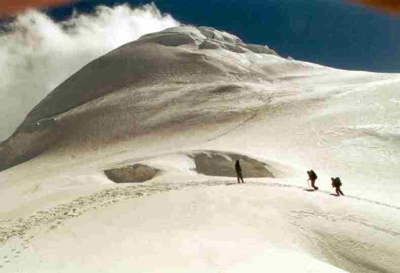
Back in Na, we set up our tents and around 3 PM welcome the five, very tired, top climbers. To quote Jeroen, "never been so tired in my life". Everyone succeeded although the first 100 meters up the glacier along a 60 degrees ice slope [1] was tricky as no one was using the fixed rope.
At night I spot a light on the Tsho Rolpa moraine dam which seems unreal but we think we saw a house with a blue roof during the day. Tonight I have a very long sleep with spooky dreams, catching up from the past two nights. I wake up noticing a white cover on the tent.
Tonight we got 20 cm of snow [1]. Breakfast ends with throwing snowballs and we move up along the river to Tsho Rolpa, a large lake (= tsho) with a 200 meter high glacial dam that may break in the future. We pass telemetric equipment to gauge suddenly rising water from a glacial lake outburst flood, very modern equipment in a primitive environment.
On top of the glacial lake moraine dam [1][2] we see how an International Aid Project made a strong channel and lock in the moraine dam [1][2][3] with a capacity of up to 34 cubic meter per day. Normally, 14 cubic meter per day is sufficient to keep the water level stable. The lake level was brought down five meters and this will help to prevent overflow of water if one of the hanging glaciers slide in the lake. We also see a building powered by solar cells and big tanks of fuel. This is very impressive on the one hand but also unreal at 4600 meters. In the house a man lives permanently, neatly dressed with yellow Wellington’s and I can hear the hissing sound of a two-way radio.
Tonight we camp below the Tsho Rolpa moraine dam near a cave and between rock fences used for cattle [1] and this shields us from the cold wind. During lunch we suddenly hear "pani, pani" and it turns out cooky burned his hands cooking a large cake. After cooling in ice cold stream water for half an hour he still has several blisters.
Cooky and the other Sherpas occupy the cave, roughly 8 - 6 meters with a few natural bunk beds and a low ceiling. An amazing structure carved out by human hands. I join them in the cave after dinner and inquire about cookies hands. He is not cooking, just giving orders to the kitchen boys and it may take several days to heal. They pass around the cake, neatly sliced in 20 pieces. We only took 30% and they seem to enjoy it as a starter for the Dhal Bat dinner, rice and vegetables. This is the only time you will see them drinking water in large quantities and this always surprised me. We also spot the local rat but nobody is concerned it will touch the food. Our Buddhist Sherpa guides are always very harmonious with animals but I also have seen them throwing small rocks at an eagle in the Kangchenjunga area they could never hit.
The atmosphere is very pleasant and it feels relatively warm compared to the freezing night outside. The Nepalese are constantly talking and making jokes. At 10 PM I happily leave them and go to bed. These two hours after dinner are a real bonus. All the other group members are already in their sleeping bags for a long night, from 8 PM to 6 AM. I would get a sore back and always try not to hit the sleeping bag before 9 PM . Beside the company of the Sherpas at night, I also enjoy to walk around in the camp and watch the stars of the Milky Way, a beautiful bright cloud only visible in remote areas far away from the bright artificial lights of civilization.
Today we walk along and across the Tsho Rolpa glacier. The path quickly takes us up as this the only way through the rocky and mountainous terrain. During a tiring climb I collect moss to be analyzed for heavy metals in this pristine area. During the oil fires of Khuweit in the early nineties, some of the snow of the Himalayas was reported to be black and I am curious how much pollution there is in the area. In the Canadian High Arctic near Eureka I was surprised to see so much plastic, rope and wood and other human waste from down south along the beach, an area covered in sea ice for ten months of the year.
We have a nice view at the Tsho Rolpa lake to the West [1] and Tsho Rolpa glacier to the East [1]. We go down again across boulders, often sliding down, and start crossing the rocky glacier [1]. The track is almost non-existent, up and down all the time, often consisting of loose rocks and very tiring for walking.
After several hours and often grasping for air at this altitude of 4800 - 4900 meters, we finally arrive at the top of the Tsho Rolpa Glacier, enclosed by high mountains and glaciers [1]. We witness an avalanche [1] and somewhere on the left side of the 200 meters high glacier and rock faces, there should be a track towards the Trashi Labtse Pass but I can't spot it.
Our camp is set up on top of rocky ground where even walking is difficult due to numerous large, loose boulders [1][2][3].
Last night was not cold but again sleepless and with headaches. I consult Phurba and we decide that Ron, Paul and I will cross the pass to Tengpo at 4300 m and not sleep at 5756 meters on the Trashi Labtse Pass to avoid the risk of altitude sickness. First I take a full Diamox to ensure that my body will not collapse half-way and drink two liters of warm water. We have breakfast together with the kitchen crew in a crowded tent. I only have rice for breakfast and was not feeling like having eggs now.
The nearly invisible track takes us to a rock face with a steep (4a) traverse secured by ropes. For us it is relatively easy but for the porters with their 25 kg loads this is more difficult [1]. We move up along a steep rocky trail and we are amazed how easily the porters cross the difficult spots. Finally we reach a relatively flat glacier [1] and this time the ice is visible but the surface uneven and in part rocky which, combined with the 5400 meter altitude, make it tiring.
At 11.30 we have lunch on the glacier and can now see the lower part of the Trashi Labtse Pass 400 meters up along a steep glacier, dotted with several porters and trekkers moving up slowly and stopping constantly. This will not be an easy traverse.
I get restless and want to cut the lunch short trying to reach the pass no later than 2 PM otherwise we couldn't descent to Tengpo as arranged. However, I now sense that Phurba expects us to stay on the pass by delaying the schedule as this would make his organization easier. I don't feel like it as I would risk being ill for several weeks after coming home when spending another night at high altitude.
Soon Ron, Paul and I move up and this is very hard. Steep, slippery and tiring, even when following old tracks. In a steep spot there is a fixed rope. Without a ski pole, it is impossible to ascent and the small six-point crampons would be very useful but these are packed. Only a few tourists use their crampons. Higher up, one of the kitchen boys passes us [1], using an aluminum snow bar as ice axe.
This is a steep area and one should not slide down; the experience is a bit frightening. However, the panoramic view of the valley glaciers [1] is rewarding for the hard and tricky route. I overtake an older German trekker wearing crampons going up steadily. Near the pass [1] Migma comes down to help us. He offers to carry my rucksack but I decline. Jaco is coming up in a steady pace and never takes a rest, a true lead top climber.
At 2 PM we are on top of the pass and can now see the Parchamo Peak [1] on one side and High Camp near the huge rock face with small dots of tents at its base [1]. This is a relief as we are now at 5700 meters and we (Paul, Ron and I) reached the pass safely. We have another four hours to go down from 5700 to 4300 meters before it gets dark near 6 PM.
We quickly move down. The porters with our bags are to follow later but haven't reached the pass yet which is worrying. First there is a fixed rope at a steep glacial slope and we can now see the route down [1].
We meet the Australian group leader Paul and my smiling young porter of two weeks ago. They took one of the Australians down to Thame and had him picked up by rescue helicopter because he developed severe lung eodema, a build up of fluids in the lungs which causes severe coughing and can be deadly when not going down. They point us the track and tell us to aim for two big rocks in the far distance. Most of the route is marked with stone signs ("Steinmanchen").
We move down across loose rocks while a few rocks up to half a meter across come tumbling down from above every few minutes. This feels like war but at least you can see the "bullets" coming. Going down 1500 meters along the glacier takes much longer than expected due to the long, rough, up and down going track, at times invisible and we are getting very tired.
After 3 hours, around 5 PM we finally leave the glacier and the moraines and follow a comfortable path. Tengpo must be somewhere over here. Will it have shelter? Our porters, if they followed us are nowhere to be seen in the far distance and we get a feeling that we may have to spent the night in the open. Paul is not worried as he carries his sleeping bag, he announces proudly. "Always carry your sleeping bag".
The next 45 minutes at a high pace seem to take forever and we are getting extremely tired. Just before it gets dark, at 5.45 PM, we finally spot several tents of a tourist group and a few shepherds houses of Tengpo, one with a tea house sign [1][2]. Food and shelter for the night!!!
When we take off our pack it is pitch dark and we are happy that we rushed down as walking at night is not to be recommended for tourists. The teahouse offers us a meal and shelter but we wonder where we will sleep. There is only a single room with an open fire in the middle and are enjoying the local culture.
Two hours later our three porters arrive in the dark night. They are extremely tired, shaken and unhappy. They only carry our bags and have no tents. They must have had a rough time in the last 2 hours in the dark on the moraine field. A meal, tea and bottles of Nepali rum make up for the rough day and we are all smiling now. Together with the owner, his wife and baby we will spent the night on the floor of the room occupying every flat space. This is the best sleep I have had for the last few days and I wake up waiting for the warm sun to appear above the mountains visible through the open door as it is still freezing cold outside. One of our porters lies very close to the fireplace and keeps his feet bent not to touch the hot ashes.
The trekkers group camping here is from San Francisco and they are all above 55 year old, moving slowly but steadily. Their cook and Sirdar are from the same village as our cook. Cooky tells us he lives in San Francisco for part of the year, working illegally in an Indian Restaurant. I write down his address.
We make our way to Thame and soon overtake the slow Americans. One of them has a solar panel on his pack to power a video camera. We are in high spirits, feel as if we escaped and are of course very strong after spending ten days above 3000 meters.
Thame [1][2][3] appears already after one hour and has a beautiful monastery [1][2][3][4] 100 meters up the hill. The houses and stone walls surrounding the fields are very pronounced in the morning sun and on the far side we can see the hydro-electric water basin used for generating power for the region of Namche Bazaar.
We check into the Everest Summit Lodge [1] of Appa Sherpa and have French Fries for lunch. Welcome to the world of tourism but, for the first time in weeks we will sleep on a level bed, walk on level floors and sit in a heated room at night. The toilet is still an outhouse 100 meters down a path but has a flush consisting of a can of water. The first body wash in 10 days using a big bowl of warm water feels good but at this altitude and temperature you don't really need it.
During lunch Migma arrives as arranged and asked us not to go to Khumjung and Tengboche the next day as planned, as the other five group members will join us tomorrow. He only took 3.5 hours to go down to Thame and doesn't look tired but we would have needed 4.5 hours at top pace.
Thame gets some 50-100 tourists a day, usually on a day hike from Namche Bazaar, visiting the monastery. We talk to several tourists. A man on his own with his typical Andes woolen head has been on the road for months. He knows all the places for meditation in Nepal and Thailand. There is also an international group of dentists who visit the various villages a few times a year for dental care.
The Australian group is here as well and they all look tired. They spent three nights on the Trashi Labtse Pass. Most of them have never been above 4000 meters before and called it an extremely heavy trip wondering why they ever signed up.
Appa Sherpa, our lodge owner, has been to the top of Mount Everest 11 times, a world record, and invests all his earnings in this lodge. In May 2001 he will go again. Will he survive the 12th attempt? Everest is difficult and many excellent climbers get caught in avalanches for which there is no defense.
I wonder why there are no books written on Sherpas climbers except Tenzing Norgay who was the climbing partner of Hillary when they reached Everest in 1953. The Sherpa version of the climbing stories is often so much different, less heroic and more realistic. E.g. it is well know among the Sherpas that if you spent one night on the South Col (8000 m) of Mount Everest, you will have orientation problems for a few months back home caused by brain damage. I suggest he should get a ghost writer, similar to Tenzing Norgay which book has a total different outlook on mountain climbing dealing with hardship, survival and personal dilemmas, i.e. true life.
Tinight I slept for 12 hours, had weird dreams and wake up with a stiff neck but this was a good sleep.
We visit the monastory [1][2][3][4] and have a view at the main North valley towards Tibet. This reminds me of the photographs given to me in Holland by Louise who traveled up this valley to Tibet illegally in the early nineties. She called the crossing of the 5600 meter high pass the most tiring journey of her life. The photographs are portraits of Pempote and her family, the female owner of the Sagamartha Lodge where she stayed. The lodge is now closed but Appa Sherpa shows me the house that is in the middle of Thame [1](left house).
During lunch I try a visit and show a reluctant Pempote the photographs. She has a severe toothache but invites me for a Dahl Bat lunch in the traditional Sherpa lodge with Tibetan carpets and large copper colored storage pots. Her husband and the two children on the pictures are in Kathmandu, in the trekking business she tells me, and only her two youngest daughters are at home. She is very emotional seeing pictures of seven years ago and I sense a lot has happened since. It is very quiet and a bit chilly inside and I don't see any of the pictures Louise sent seven years ago so she probably never received them. Getting involved in the private life of this Sherpa family gives me mixed feelings. Are they still happy?
On the second day in Thame the ceiling drops to the village level. Is this the beginning of the common heavy snowfall in the second half of October? Late in the afternoon our group arrives and they all look fine. Jaco, Meinhard and Reinhard made it to the top of Parchamo and this was hard due to the steep track [1]. Standing on top must be a sensation and a relief at the same time [1][2][3].
We leave for Namche Bazaar and I am taking the Sherpa Express, rushing past astonishing tourists. Phurba, Tendy and cooky are in a hurry and instead of 3 hours we do it in 1.45 hours. Phurba makes one of his many philosophical remarks, "They think you must be an important man as you have 3 Sherpa Guides for yourself". Interesting remark, I feel like it but of course I am not and I think of Jimmy Carter who did trek in this area in the late eighties. Another saying he used at the start of the trek was: "Some people fight to look important". Very true.
We meet several Yak caravans [1][2][3] of Tibetans carrying inexpensive Chinese goods to the market of Namche Bazaar. Mostly blankets, carpets and clothing. In the river beds you can see evidence of the glacial lake flood of the middle seventies that destroyed the power generator near Thame.
Namche Bazaar [1][2] is the largest town in the area an the prime visiting spot for tourists. From here you can go to Gokyo, Tengboche, Everest Base Camp, Thame, Khumjung or walk up hill to see Everest and return as most Japanese do. The elevation of 3400 meters gives altitude sickness to ignorant tourist and the cool weather is a far difference from a typical holiday resorts. The booming tourist industry seem misplaced and may only be temporary but I do find it a pleasant town if you ignore the numerous tourist shops and restaurants.
The Tibetans traders at the market [1][2] are rough looking men staying in their simple tents with no floor but carrying solar cells and large rechargable batteries. They must have been on the road for weeks.
Tonight we go to a bar-disco to have beer which I initially resist. Funny feeling, dancing at 3400 meters on music of Madonna, Rolling Stones, Chuck Berry and other classics. Some tourists, including Reinhard give a jazzie singing performance [1]. At 2 Am I see Phurba hanging on the bar and he is about to collapse being drunk and sick of several rums. After throwing up in a toilet we take him home walking like drinking buddies and put him in the tent. He still has full control and manages to cover up for a long rest.
As we have a spare day we will visit the monastery of Tengboche. Going up hill, I meet Appa Sherpa again and we soon leave the village. After one hour walking along a wide nearly level path we see the pyramid of Mount Everest towering above the Nuptse Ridge from behind. A nice view.
Down to the river, crossing a hanging bridge [1] and up some 600 meters to Tengboche. The cow and yak caravans steadily going up and we have to hurry at times not to get stuck in between. My second time in Tengboche is a disappointment, a nice monastory but three lodges and numerous tourists. The monastory is closed today in preparation for an important visitor tomorrow.
We go down towards Pangboche and here are 3 nice lodges among trees but these are all full. Migma takes us to a simple Sherpa lodge where we will sleep in a dormatory.
In the morning we try to visit the monastory (www.tengboche.org) again and it turns out the Lama of Junbesi, the highest lama of Nepal, will arrive at Tengboche by helicopter at 9 AM.
The welcome ceremony [1][2][3][4] [Head Lamas of Junbesi and Tengboche] is very special, with colorful dresses of monks among the worlds tallest mountains [1], Mount Everest, Lotse and Ama Dablam. I let old Sherpas pass by to get a glimp of the Lamas. They join the procession and enter the monastory but all the tourist have to stay outside. Even Phurba is not admitted.
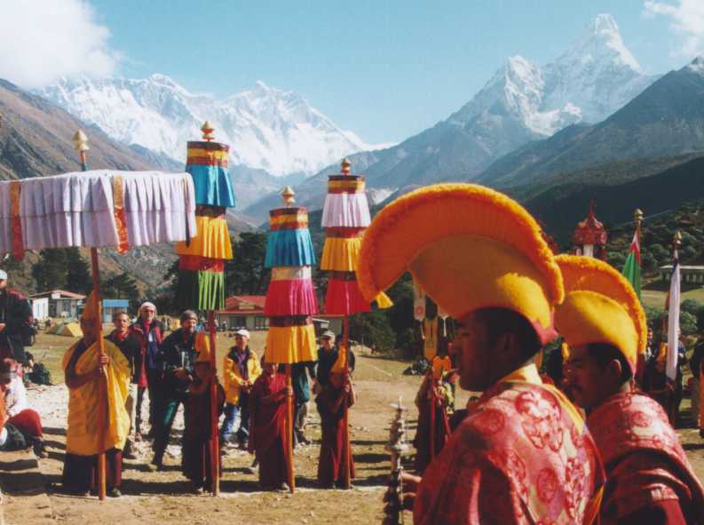
Welcome ceremony for the Lama of Junbesi with colorful dresses of monks among the worlds tallest mountains, Mount Everest, Lotse and Ama Dablam.
We go back to Namche Bazaar and some of us race down the hill of Tengboche, just like 3 years ago when coming back from Island Peak passing several astonished trekking groups. Paul looses his footing twice while passing an Italian group getting upset from our pace.
After lunch in Namche Bazaar, we repeat the race going down 400 meters but a kitchen boy is clearly faster. We cross two hanging bridges [1] in wooded river valleys.
At noon we arrive in Lukla and Phurba and I visit his uncle and nephew Ang Phurba who was on my trek to Island Peak in 1997. Next he drags me into a pool house of one of his uncles and the looser will pay for the game. Here he learned playing pool only half a year ago.
Tonight we have a singing and dancing farewell party and at the end all the Nepali get a tip of roughly 10% of their wage. We are expecially grateful to Phurba [1] who helped to make our trip a success. He gives us the rare compliment that we were a true group as everybody was happy.
At 5 AM we get up and at 6 AM are ready to take our equipment to the check in counter of the air strip. We are on the first flight [1] and arrive in the early morning in Kathmandu. The busy city is a stark contrast to the quiet country side of the high mountains.
Visit to the Tibetan refuge camp, to be completed.
Visit Silver Shop and Jos Bus, to be completed.
Another trip to Nepal ended, a primitive trip of four weeks. The prolonged high altitude visit will keep my red blood cell level abnormally high for another 2 months and feels as if "I visited the Buddha".
Jean van Berkel, Amsterdam, 12-3-2001
Overview of photographs and authors:
* Low country (below 3400 m) from Jean van berkel
* High country (above 3400 m) from Jean van Berkel
* Photos from Reinhard Haster
* Photos from Jaco Liefers
* Photos from Jeroen Noyen
* Photos from Jacoline Schreuder
* Photos from Ron Steenaert
* Photos from Paul Stevelmans
![[1]](pa_rei12.jpg)
![[1]](par110.jpg)
![[1]](pa_rei10.jpg)
![[1]](par108.jpg)
![[1]](par50.jpg)
![[1]](pa00_p9.jpg)
![[1]](par55.jpg)
![[2]](par56.jpg)
![[1]](pa_rei11.jpg)
![[1]](par53.jpg)
![[1]](par52.jpg)
![[1]](par51.jpg)
![[1]](par54.jpg)
![[1]](par60.jpg)
![[1]](pa_ron15.jpg)
![[2]](pa_ron16.jpg)
![[3]](pa_ron17.jpg)
![[1]](pa00_p1.jpg)
![[1]](par61.jpg)
![[2]](par61a.jpg)
![[1]](par67.jpg)
![[1]](par73.jpg)
![[1]](par74.jpg)
![[2]](par71.jpg)
![[1]](par62.jpg)
![[1]](par65.jpg)
![[1]](par57.jpg)
![[1]](par75.jpg)
![[1]](par76.jpg)
![[1]](par64.jpg)
![[2]](par72.jpg)
![[1]](pa00_p5.jpg)
![[2]](pa00_p6.jpg)
![[3]](pa00_p7.jpg)
![[1]](par63.jpg)
![[1]](pa00_p10.jpg)
![[2]](pa00_p11.jpg)
![[3]](pa00_p12.jpg)
![[1]](par2.jpg)
![[1]](pa00_p3.jpg)
![[1]](par3.jpg)
![[2]](par4.jpg)
![[3]](par5.jpg)
![[1]](par1.jpg)
![[1]](rol302.jpg)
![[1]](par6.jpg)
![[1]](par8.jpg)
![[1]](par9.jpg)
![[1]](pa_rei15.jpg)
![[1]](pa_ron10.jpg)
![[1]](pa_rei14.jpg)
![[1]](par7.jpg)
![[1]](par10.jpg)
![[2]](par11.jpg)
![[1]](par12.jpg)
![[2]](par13.jpg)
![[3]](par14.jpg)
![[1]](par15.jpg)
![[1]](par16.jpg)
![[1]](par17.jpg)
![[1]](par18.jpg)
![[1]](pa00_p4.jpg)
![[1]](pa_rei22.jpg)
![[1]](pa_ron11.jpg)
![[2]](pa_ron12.jpg)
![[3]](par19.jpg)
![[1]](pa_rei13.jpg)
![[1]](pa_rei19.jpg)
![[1]](pa_ron21.jpg)
![[1]](pa00_p8.jpg)
![[1]](pa00_jl1.jpg)
![[1]](pa_rei17.jpg)
![[1]](pa_rei20.jpg)
![[1]](pa00_jl3.jpg)
![[2]](pa_rei21.jpg)
![[1]](par20.jpg)
![[2]](par21.jpg)
![[3]](par22.jpg)
![[1]](pa_ron18.jpg)
![[2]](par24.jpg)
![[3]](par25.jpg)
![[4]](par26.jpg)
![[1]](par23.jpg)
![[1]](pa00_ja3.jpg)
![[1]](pa00_ja4.jpg)
![[2]](pa00_ja5.jpg)
![[3]](pa_rei16.jpg)
![[1]](pa_ron22.jpg)
![[3]](par28.jpg)
![[1]](par27.jpg)
![[2]](par33.jpg)
![[1]](par29.jpg)
![[2]](par30.jpg)
![[1]](pa00_j5.jpg)
![[1]](par34.jpg)
![[1]](par40.jpg)
![[2]](par41.jpg)
![[3]](pa_re33.jpg)
![[4]](pa_re31.jpg)
![[Head Lamas of Junbesi and Tengboche]](pa_ron19.jpg)
![[1]](par35.jpg)
![[1]](pa_ron14.jpg)
![[1]](pa_ron13.jpg)